


Étape 1 Puy en velay Monastier sur gazeille

drkb
User
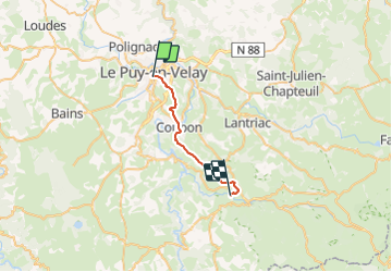

Length
20 km

Max alt
992 m

Uphill gradient
697 m
Km-Effort
29 km

Min alt
623 m

Downhill gradient
503 m
Boucle
No
Creation date :
2023-08-28 07:19:03.998
Updated on :
2023-08-28 13:52:48.628
2h39
Difficulty : Very difficult

FREE GPS app for hiking
 SityTrail
IGN / Geographical institutes
SityTrail Plus
The world is yours!
About
Trail Walking of 20 km to be discovered at Auvergne-Rhône-Alpes, Haute-Loire, Le Puy-en-Velay. This trail is proposed by drkb.
Positioning
Country:
France
Region :
Auvergne-Rhône-Alpes
Department/Province :
Haute-Loire
Municipality :
Le Puy-en-Velay
Location:
Unknown
Start:(Dec)
Start:(UTM)
569726 ; 4987970 (31T) N.
Comments